


The Asia Maritime Transparency Initiative, under the Center for Strategic and International Studies, has affirmed that aerial surveillance photographs published in early February by the Philippine Daily Inquirer reinforce a message that AMTI had delivered, most recently in December: Artificial islands built up by China in the South China Sea/West Philippine Sea “now host substantial, largely complete, air and naval bases, and new construction continues apace despite diplomatic overtures between China and its fellow claimants.”
AMTI aggregates information from news sources, as well as specially designated research and nonprofit organizations, public sector institutions in Asia, and individuals.
In the case of Subi (Zamora) Reef, part of the Spratly Islands archipelago, the object of concern weighs heavily on the fact that its location is just over 12 nautical miles from the main Philippine-occupied feature of Thitu (Pagasa) Island a mere 480 kilometers westward from Puerto Princesa City.
See also:
Golez asks: Why is PH govt not protesting ‘militarization’ of Subi Reef?
Former national security adviser Roilo Golez has wondered out aloud why the Duterte administration is not doing something about China’s “militarization” of Subi or Zamora Reef, which he said is part of Philippine territory based on a law defining the country’s archipelagic baseline.
“Zamora Reef is part of the Philippine territory under RA (Republic Act) 9522,” said Golez, former Parañaque City representative and chair of the House Committee on Defense, in a Facebook post last Saturday, February 17.
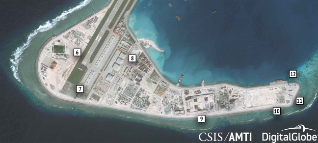
Analysis of various surveillance and other photographs captured by satellite include the following observations:
- Buried storage facilities, presumed to be for fuel, water, or other base necessities.
- A sensor/communications facility topped by a radome.
- Mobile shipping crane used to transfer cargo between ships and dock facility. In the satellite image, it can be seen at the middle of the dock next to several ships, while in the Inquirer photo it is at the eastern end of the dock.
- One of the four point defense facilities built around the base in 2016.
- A large lighthouse.
- The over 3,000-meter airstrip, completed in early 2016.
- Hangar space for 20 combat aircraft, completed by late 2016. Another four such hangars stand at the northern end of the runway.
- Four bigger hangars for large aircraft, completed in early 2017.
- Underground storage tunnels, likely for ammunition and other materiel, built during 2017. Identical buried storage facilities can be found on Fiery Cross and Subi Reefs.
- A high frequency “elephant cage” radar array, so called because the circular construction of the antennae resembles a tall fence.
- One of the four point defense facilities built around the base in 2016.
- Hardened structures with retractable roofs believed to be shelters for mobile missile launchers, completed in 2017.
In the Inquirer photo, AMTI indicated, the top of the radome for the nearby tower, which will presumably be used for targeting, can be seen assembled on the ground, awaiting installation.


