


MANILA, Philippines — (UPDATE 2 – 1:02 p.m.) Tropical storm “Jolina” (international name: Pakhar) intensified further late Friday morning as it moved towards landfall, expected to be in the Isabela-Aurora area in the evening.
Jolina was last tracked 210 kilometers southeast of Casiguran, Aurora packing winds of 80 kilometers per hour with gusts of up to 95 kph and moving west-northwest at 19 kph.
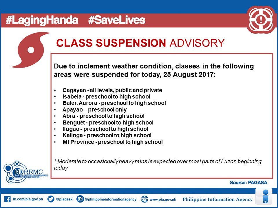
The Philippine Information Agency shared the following advisory on class suspensions due Jolina issued by the National Disaster Risk Reduction and Management Council:
The Philippine Atmospheric, Geophysical and Astronomical Services Administration has raised tropical cyclone warning signal No. 2, meaning winds of 61-120 kph are expected in 24 hours, over the following provinces:
- Isabela
- northern Aurora
- Quirino
- Kalinga
- Mountain Province
- Ifugao
- Ilocos Sur
- Benguet
- Abra
- La Union
- Nueva Vizcaya
Signal No. 1, meaning winds of 30-60 kph are expected in 36 hours, is up over:
- Cagayan including the Babuyan Islands
- Apayao
- the rest of Aurora
- Ilocos Norte
- Nueva Ecija
- Pangasinan
- northern Quezon including Polillo Island
- Catanduanes
- Camarines Norte
- Camarines Sur
Rainfall within Jolina’s 400-km diameter is expected to be moderate to heavy.
Pagasa advised people in the path of the storm to stock up on food, water, and batteries for wireless radios and flashlights, stay inside a concrete structure, and make sure their cell phones are fully charged.
Weather specialist Dr. Nikos Penaranda said stormy weather should be expected starting Friday afternoon in areas along Jolina’s route, making land travel risky from possible landslides and floods that could close down roads.
He also strongly discouraged sea travel and activities along coasts.
“Damaging floods” can be expected in Aurora, northern Quezon, Nueva Ecija, and portions of Bulacan on Friday, said Penaranda.
Saturday, the same areas, as well as Nueva Vizcaya, Quirino, and Region I provinces could experience flooding, too. These areas would have accumulated a lot of rainfall by Sunday, Penaranda said.
Metro Manila and the Bicol region can expect moderate to occasionally heavy rains on Friday night and Saturday.
Pagasa hydrologist Richard Orendain said they are keeping an eye on Ipo Dam, Ambuklao Dam, Binga Dam, La Mesa Dam, and Magat Dam as these are close to filling up.
There would be a “pre-release” of water (meaning they would be opening one gate) at Magat and Binga dams at 5 p.m. on Friday.
Jolina is expected to make landfall over the Isabela-Aurora area between 8 to 10 p.m. then cross Aurora, Southern Isabela, Quirino, Nueva Vizcaya, Ifugao, Benguet, Mt. Province, La Union, and Ilocos Sur.


